


Arctic geopolitics: China’s remapping of the world

China’s ambitions in the Arctic are suggestive of a new geopolitical perspective. How do maps visualise the Arctic Silk Road, and China as a ‘near-Arctic state’? And what does this mean for Arctic politics? Jochem Vriesema explores the role of geography in China’s Arctic strategy, by analysing two important maps.
To explain why China must be seen as a so-called ‘near-Arctic state’, Admiral Yin Zhuo of the People’s Liberation Army Navy, also known as the Chinese Navy, controversially stated that “the North Pole and the sea area around the North Pole belong to the commonwealth of the people of the world, and as China has one-fifth of the world’s population, its role in the Arctic is very much not being absent”.
China’s ambitions in the Arctic are suggestive of a new geopolitical perspective or vision – also referred to as an imaginary. The term ‘near-Arctic state’ is in itself a new imaginary worth analysing, just like China’s geographical visions concerning its Arctic policy.
Instead of emphasising China’s Arctic history or economic projects and plans as set out in Chinese policy documents
An important way to study ideas, visions and plans, and how they affect the spatial and political configuration of the Arctic, is to focus on the related representations and visualisations of geography. The question is: How do maps visualise China as a near-Arctic state? And what does this mean for Arctic politics?
Geography as detrimental to understand Arctic politics
To understand why China wishes to be seen as a near-Arctic state, an explanation is needed on why geographic factors are quintessential in Arctic politics. The following two examples will illustrate this.
Firstly, the most significant international agreement regarding the Arctic Ocean is the 1982 United Nations Convention on the Law of the Sea (UNCLOS). Coastal states (Canada, Denmark, Norway, Russia and the United States) have sovereignty in their so-called Exclusive Economic Zone (EEZ) and can extend their sovereign rights in maritime areas over their ‘continental shelf’, a shallow extension of the continent’s landmass under the ocean. The continental shelf is a geological condition that can be seen as a matter of geography.
The region has become subject to Arctic policies, constructed by both Arctic states and the so-called non-Arctic states
Secondly, geography determines the composition of the Arctic Council, the most prominent forum that guides Arctic governance. There are eight permanent members of the Arctic Council: Canada, Denmark, Finland, Iceland, Norway, Russia, Sweden and the US.
Since these states have territories within the Arctic, they carry the role as stewards of the region.
As the Arctic has witnessed a significant increase in political interest, the region has become subject to Arctic policies constructed by both Arctic states and the so-called non-Arctic states. The latter, mainly to be found in Europe and East Asia, are actively seeking ways to become a stakeholder in the region.
Non-Arctic states wish to be heard in future areas of Arctic governance, as they have concerns in terms of environmental, economic and military security in the Arctic, which have global effects.
Non-Arctic states can only participate in the Arctic Council as observers. Among the thirteen Arctic Council observers, two states directly refer to geography whilst seeking their status of Arctic stakeholder: the United Kingdom and China.
The UK aims to gain recognition by Arctic states and non-Arctic peers by emphasising its identity of the ‘nearest neighbour’, nodding to the Shetland Islands. China wishes to be acknowledged as a near-Arctic state. The focus will be on the latter.
World Island
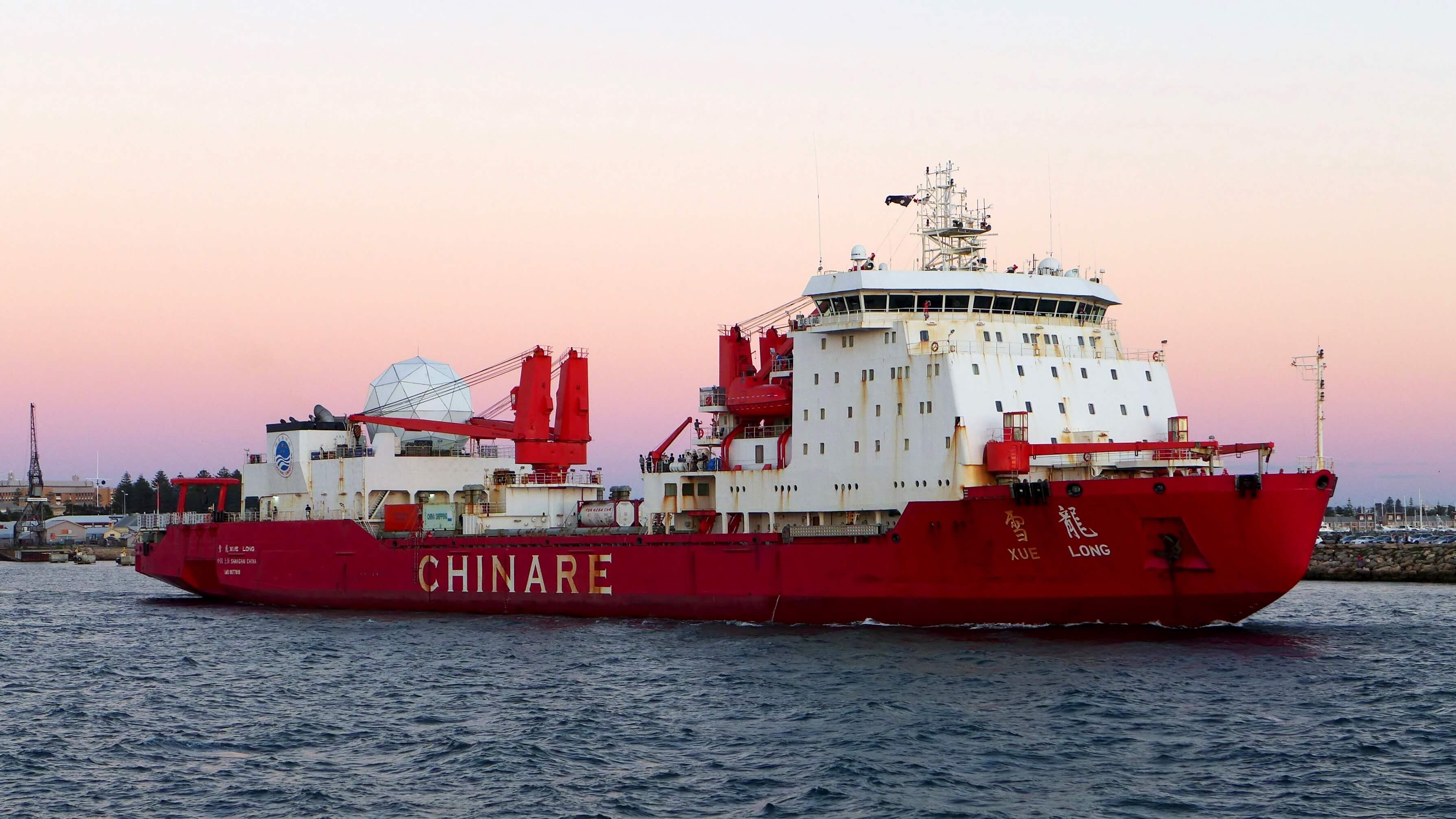
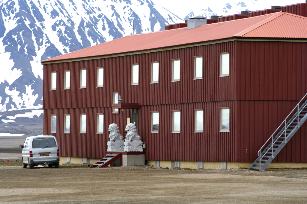
China’s history in relation to the Arctic started with signing the Spitsbergen Treaty in 1925, which recognises sovereignty of Norway over the Archipelago of Spitsbergen and grants equal rights of commercial activities on the islands to all signatories of the treaty. China obtained observer status in the Arctic Council in May 2013, which eventually led to the publishing of a much-anticipated white paper in 2018.
This white paper envisioned China’s ambitions for an Arctic Silk Road, which is integrated in the larger Belt and Road Initiative.
The map completely resets the ‘standard’ vision of the world, emphasising the significance of the world oceans and polar regions
The perfect example of how China changes its way of looking at the world, is China’s vertical world map (figure 1). Hao Xiaoguang, a geophysicist from the Chinese province Wuhan, created this world map.
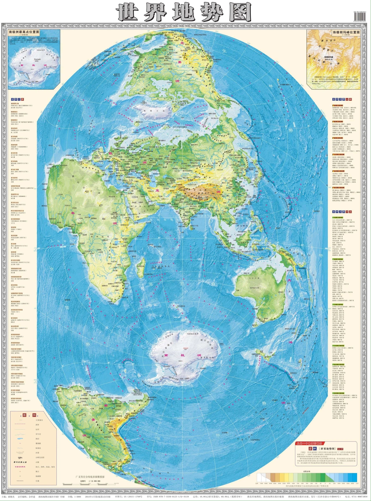
Since 2004, this map has been used by China’s State Oceanic Administration for Arctic and Antarctic voyages, as well as the People’s Liberation Army (PLA) – China’s army – which utilised it since 2006 as an official military map.
On a traditional world map, the Arctic and the Antarctic can be found on the edges of the world. China’s new vertical world map is different. The map is dominated by a peacock-shaped Antarctic continent, and the Arctic region is depicted as a central ocean, ringed by North America and Europe.
Halford Mackinder, a British geographer, politician and academic, wrote in 1942 that “each era has its own geographical perspective”.
Firstly, the map completely resets the ‘standard’ vision of the world, emphasising the significance of the world oceans and polar regions.
It is not a surprise that China is centred in this new world order, where it is visually dominating the Asia-Pacific
Secondly, the map exposes what Mackinder described as the ‘World Island’ (also referred to as ‘Afro-Eurasia’). The World Island is the combination of the three interlinked continents of Africa, Asia and Europe.
Thus, the observer of China’s new map is confronted with how the different land masses, big continents and smaller islands are connected into one interlinked and inseparable world, surrounded by vast oceans.
It is not a surprise that China is centred in this new world order, where it is visually dominating the Asia-Pacific. China has pushed away dwarfing Europe, as well as the US – which together with Canada is upside down and seems to almost fall off the world map.
Unsurprisingly, the World Island is also the geographical focus of China’s Belt and Road Initiative, and – a Chinese interpretation of Mackinder’s theory – the geographical perspective of this era. This map is the visual representation of China’s new global Realpolitik: pragmatic, assertive of China’s national interests, cooperative where possible, and yet ready to face up to conflict.
The Arctic as an international economic space
The second map (figure 2) has a strikingly similar rendering of China’s Arctic imaginary. Again, the map shows that, in China’s imaginary, a major remapping of the world is underway. This remapping shows an image of the world which is dominated by the World Island.
A difference between the vertical world map in figure 1 and the horizontal map in figure 2, is the location of the poles. In the horizontal map, the Arctic is almost placed at the centre of the map, whilst the Antarctic continent is on the left side.
No matter where the poles are placed, China can be found at the centre of the map. However, China is tilted slightly. Arguably, this tilt to the right has a reason. China’s easternmost point is now visually closer to the North Pole than on a standard world map. In this context, China can be seen as a ‘near-Arctic state’.
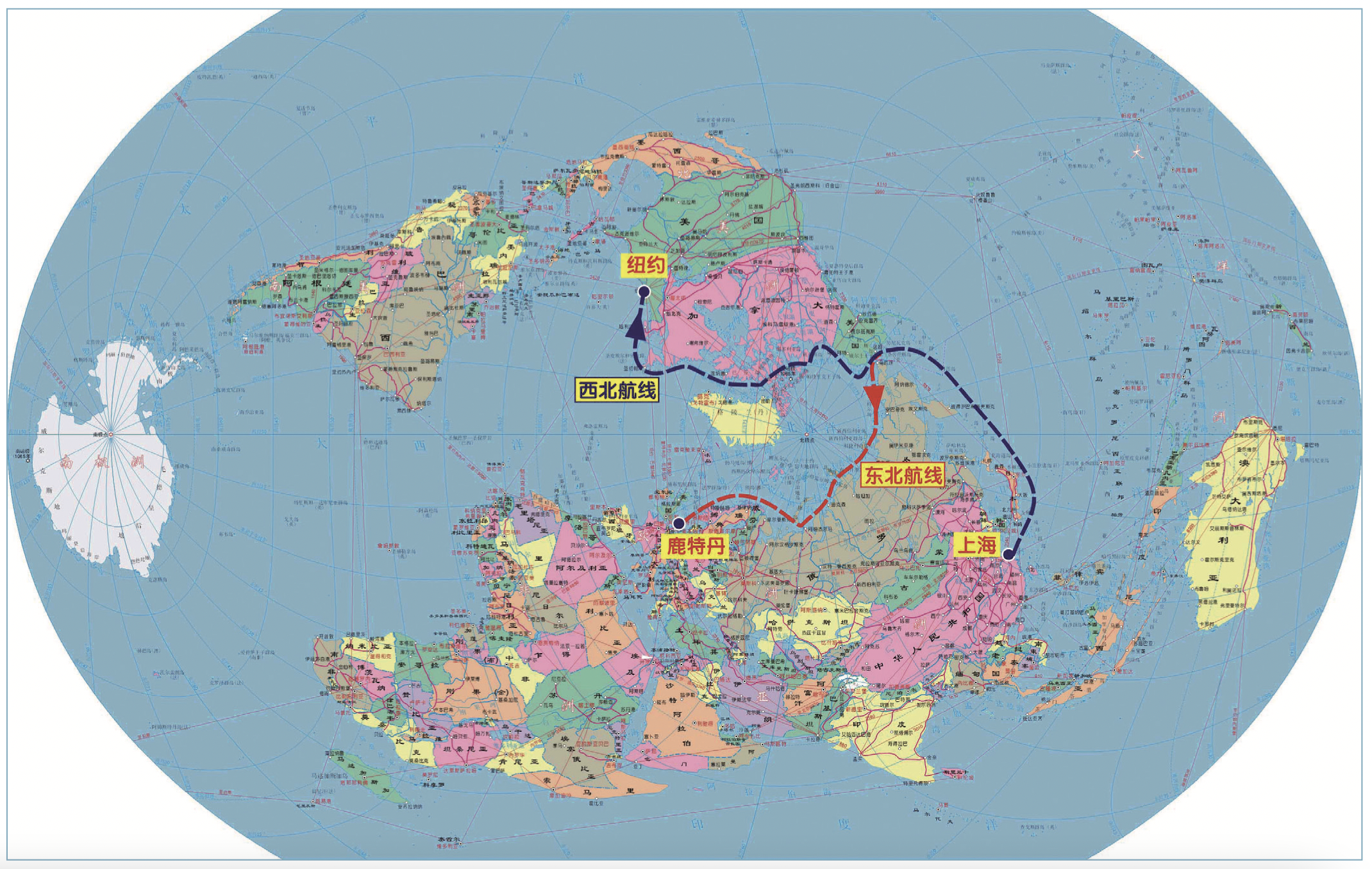
A fundamental difference between the horizontal map above and the map in figure 1 is the appearance of the two dashed lines flowing through the Arctic. The blue dashed line starts in China, Shanghai (上海) and flows to New York (纽约), via - as the textbox defines - the ‘north-western route’, also referred to as the Northwest Passage (NWP).
The red line takes another track after having passed the Bering Strait (this strait separates Asia from the US), and continues its route to Europe, more specifically to Rotterdam (鹿特丹). The textbox defining this line is translated to ‘north-eastern route’, also referred to as the Northern Sea Route (NSR). These lines show the interconnectedness of China and the rest of the world.
The NSR is the shortest shipping route linking East Asia to Europe and North America. This would provide China with a safe and reliable shipping route for importing resources and exporting Chinese products.
It is estimated that, compared to conventional shipping routes via the Suez Canal or the Panama Canal, shipping through the NSR would shorten shipping trips by at least forty per cent. This estimation is based on shipping trips between northern Chinese ports and ports in northern Europe, as well as the east coast of America.
Despite being more dependent on the Russian Federation, which controls most of the NSR, this route is more reliable for China than the alternative routes that currently pass through the straits of Malacca and the Suez Canal. This was highlighted by Russia’s energy minister after the blockade of the Suez Canal in March 2021.
What can be concluded from this map is that Arctic space is reconstructed as a network of shipping routes, which facilitates connectivity and trade without barriers
Firstly, because the traffic capacity of the latter two is at its peak. Secondly, because – especially in the Suez Canal – piracy is a large problem, and the March 2021 blockade showcased the vulnerability of the canal.
What can be concluded from this map is that Arctic space is reconstructed as a network of shipping routes. These shipping routes facilitate connectivity and trade without barriers. The map indicates that different continents can be connected to China, via and through the Arctic.
This can be related to the logic of ‘corridorisation’, as described by scholars Maximilian Mayer and Dániel Balázs. This term refers to the reconstruction of space into corridors.
There are two reasons why these corridors are visually attractive. Firstly, because of their geographical novelty. Secondly, following China’s 2018 white paper and the policy documents on the Belt and Road Initiative, it can be concluded that the lines represent more than just shipping routes.
The Chinese geopolitical vision suggests that the Arctic is becoming a space of unhindered global flow of products and connection of the world markets
The lines are a representation of modern transport infrastructures such as pipelines, ports, railways and communication networks, which would increase the connectivity of China with the rest of the world, via the Arctic. These connections have historically never existed. Thus, they can be seen as a powerful geopolitical imaginary.
To sum up, the Chinese geopolitical vision suggests that the Arctic is becoming a space of unhindered global flow of products and connection of the world markets. China, Europe and the U.S will be interconnected through the Arctic, which consequently becomes a corridor of the Arctic Silk Road.
The Chinese imaginary portrays the Arctic as a frictionless block where connectivity is not hindered by distance, borders and jurisdiction. Thus, in this perspective, the Arctic can be seen as part of a highly interconnected global economy, constructing a new type of win-win globalisation.
This map corresponds to China’s plans of an Arctic Silk Road as outlined in the 2018 white paper, emphasising a strategy of cooperation, win-win, common development and common prosperity.
However, the visions also trigger opposition, as the Arctic Silk Road is solely a Chinese project and it carries a title which refers to Chinese history. It is only the Chinese identity that comes along with the project.
For other Arctic states, this name can be worrying. Most of the Arctic states have no historical connection with the ancient Silk Road. Hence, the vision of an interconnected global economy through the Arctic Silk Road is unlikely to be perceived as a truly international initiative.
Conclusion
China’s geographical visions correspond to the argument that Beijing is seeking to ‘sell’ the idea of the Arctic as an international space. The impact of geopolitical visions (imaginaries), especially when expressed by such a major power, should not be underestimated. The question that arises is: what do these imaginaries mean for Arctic governance?
China challenges the idea of the Arctic as a fixed space which belongs to solely five coastal states (UNCLOS), or that it belongs to eight states that have a permanent seat in the most prominent instrument regarding Arctic governance, the Arctic Council, due to their geographical location.
Especially in a fast-changing geographical environment, China urges us to think beyond conventional political structures. Partly due to Arctic imaginaries such as China’s, the dividing line between Arctic and non-Arctic will fade rapidly.
This leads to new, and still unanswered, questions for the future of the Arctic. For example, can Arctic states adapt to a much more crowded clubhouse, as non-Arctic states express willingness to have a greater voice in the Arctic?


0 Reacties
Reactie toevoegen